

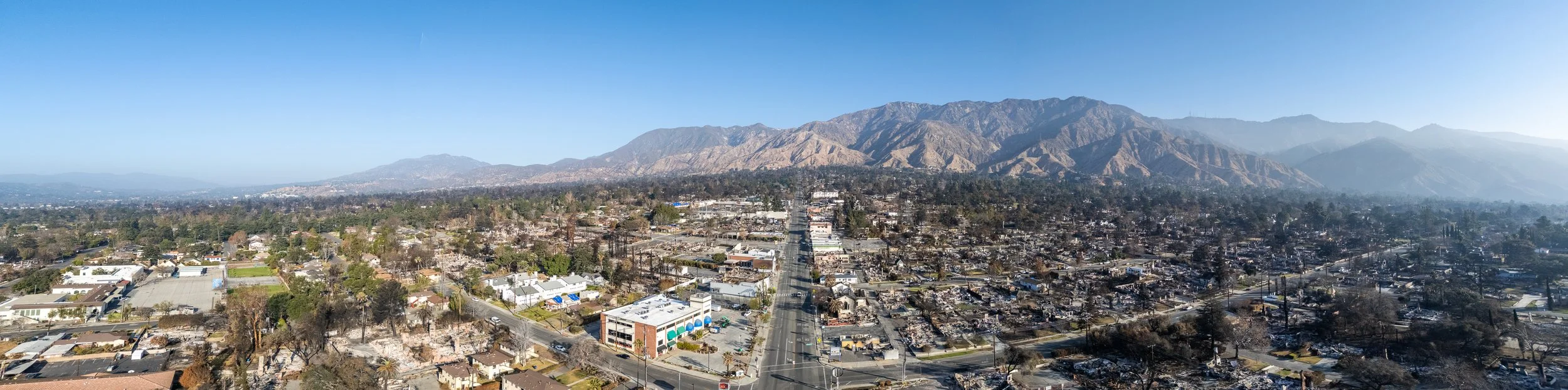
Rebuilding After Fire
Paradise, Lahaina, Pacific Palisades, and Altadena have all suffered devastating fires in recent years. However, these types of urban fires are nothing new, although not nearly as common as they once were. The Wikipedia List of Town and City Fires has 322 urban fires identified as “major conflagrations” going back to antiquity. With climate change, we should expect more fires like these recent ones, driven by extreme winds, fueled by alternating periods of excessive rain and drought. How we rebuild will determine how bad the next fires will be and how we thrive coming out of the fire.
Emily Badger had a great piece for The New York Times Upshot about what Los Angeles could learn from the great fires of the past. She looked at how Chicago, Boston, Seattle, and San Francisco rebuilt after their great fires. We can take lessons not just from these fires in the 19th and early 20th Centuries, but looking further back to cities like Lübeck in the 1200s, London in 1666, and Tokyo in the first half of the 20th Century.
Overcoming the Engineering Mindset
One of the biggest challenges I’ve had throughout my career is dealing with what I call “The Engineering Mindset.” The Engineering Mindset views design problems through a narrow lens, focused only on the specific requirements articulated to them, without paying attention to the larger context of the project. Engineers tend to be very good at addressing the hard requirements of a design, but much worse at addressing the soft requirements. Of course, this isn’t all engineers or limited just to engineers, but it’s a mindset prevalent among engineers.
An example of this is site grading. The expressed goal of a project might be to maximize the buildable area of a lot. This seems easy and straightforward, just grade the whole thing flat, and put in retaining walls where needed. However, often the engineer does not thing about the questions surrounding that decision, like whether it’s cost effective or if it creates a pleasant place to live. (Somehow, engineers always think about the drainage of a site, because if they don’t it becomes their problem later.)

Book Review: Building for People
Building for People: Designing Livable, Affordable, Low-Carbon Communities by Michael Eliason is a fascinating examination of the leading edge of new developments in Europe. The book looks at various aspects of the development process and considerations that go into building European eco-districts. Throughout the book, it compares and contrasts how development occurs in Europe with the United States and Canada (annoying referred to as “North America” throughout the book). The conclusions drawn from these comparisons is that “North America” should adopt European-style development patterns. However, these development patterns are based on such different fundamentals regarding the resources of cities and the way the development process occurs that it’s difficult to see how much of any of what’s discussed could be implemented in the United States and Canada, except for some specific building techniques.
The basic premise of Building for People is that our current patterns of development are unsustainable and exacerbate climate change and its impacts on our cities. Laying this foundation at the start of the book is brutal. The book has a forward penned by Alex Steffen, who has done more to shape my thinking about the climate crisis than any single other person. I use to read everything he wrote, and even backed multiple Kickstarters he ran to help support his work. However, in recent years, I’ve had to stop reading his work because I found it too depressing. Not that I think he is wrong, but because he presents mostly the doom and gloom of climate change instead of a more positive vision showing a future where everyone can living abundant lives while mitigating climate change. A future I believe is possible through how we build our cities.

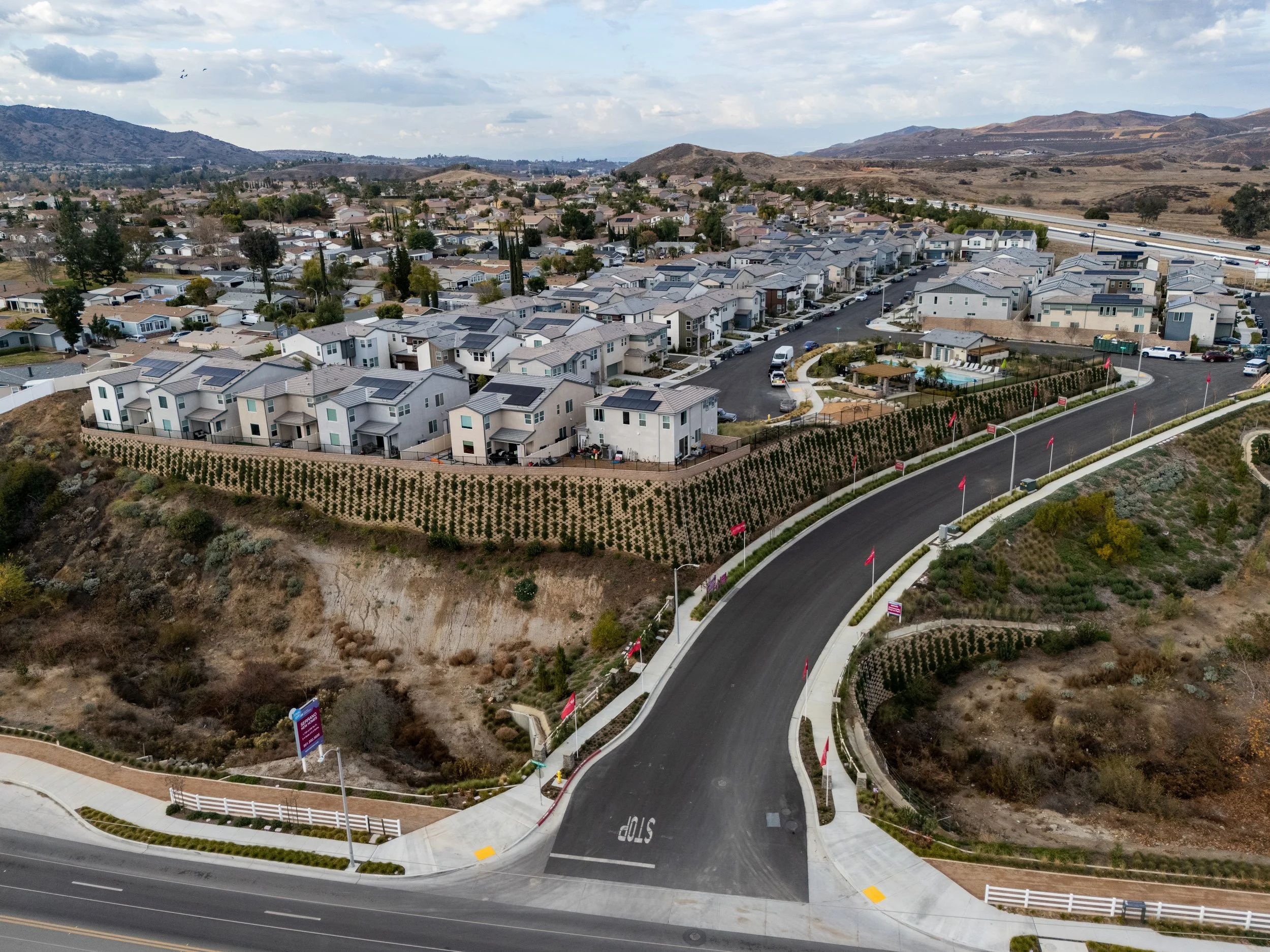
Reduce Construction Costs to Achieve Housing Abundance
One of the biggest constraints on the construction of new homes, especially in places like California, is the cost to simply build. The recent and ongoing fires in and around Los Angeles will just make the problem worse. This has been a growing problem since the Great Recession that was accelerated by the pandemic. These rising costs are driven by a constrained supply of both construction labor and building materials.
As I’ve discussed previously when look at the break even density for missing middle housing in high-cost single-family neighborhoods, construction costs directly determine how many homes must be built in order for a development to be financially feasible at a given cost of land. The higher the construction costs, the more units are needed to amortize the land cost over. In low-rent markets, the problem is even worse. In many neighborhoods in and around Los Angeles, rents and home prices do not cover the cost of new construction.

Book Review: Key to the City
Key to the City: How Zoning Shapes Our World by Sara C. Bronin is the most well rounded book on city building I’ve read in a long time. The book is ostensibly about zoning, but it covers many non-zoning issues that impact how cities feel and function as well. The only weakness of the book is that it shoehorns everything into a zoning framework, which doesn’t work for every aspect of how a city functions.
In many ways, Key to the City tires to refute some of the ideas pushed by zoning abolitionists, such as what’s found in M. Nolan Gray’s Arbitrary Lines. While many of the problems with zoning that Nolan brings up are acknowledged in Key to the City, the book maintains that zoning is a powerful tool for shaping a city. In Key to the City, Bronin contends that while zoning can stifle city building, when properly calibrated, zoning can and does enhance the economic vitality and livability of a city.

The Flood of School Traffic
My kids are back in school this week after a very long winter break. As I dropped them off Monday morning, traffic felt especially bad after not having to do dropoff for the past three weeks. As I sat there in a long line of cars, I reflected on this flood of traffic we crate every school day.
We’ve designed our roads to be a giant floodplain for cars. Our local roads act as headwater streams, feeding into the larger streams of our collector roads, and onto the rivers of our arterials. The start of the school day act like a predictable but sudden downpour. Cars leave their garages and parking spaces to arrive at the same place all at once. The result of this flood of traffic is that the roads in our residential communities are most impacted in the twenty minutes before and after the start of school.

Movie Review: Megalopolis
It’s not too often that a major motion picture by one of the greatest directors of all time makes a movie about urban planning, but that’s exactly what Francis Ford Coppola’s Megalopolis is. Megalopolis is the final film by Francis Ford Coppola, one that he originally conceptualized after the success of Apocalypse Now in 1979. Even as his stature in Hollywood grew, he could not find people willing to finance this movie, so he ended up selling part of his winery to allow him to self-finance it. The movie premiered at the Cannes Film Festival in May, where it received mixed reviews, underlined by significant amounts of bewilderment about the film.
My friend, Justin Chang, said in The New Yorker that, “the very nature of the movie, which is by turns aggressively heady, stubbornly illogical, and beguilingly optimistic, is to question our understanding of time as a finite resource.” While time is certainly a major feature of the film, as an urban planner I saw something much different.
The movie is about a city, New Rome (which looks a lot like a stylized New York, just like Gotham) that is descending into decay and debauchery. The film follows a tripartite conflict on how to handle the decline. A mayor who aims to distract the people from the decline while he tries to cling to power; a demagogue son of a powerful banker who is out to rally the mob for his own political gains; and finally, there is the hero protagonist of the film, Caesar Catalina, a visionary developer that wants to remake the city to reverse the decline.
Caesar Catalina is a Robert Moses-like figure that has seemingly unlimited power to raze communities and displace families to make way for his future development. As one would expect, this angers those who were displaced and provides a power base for the bank exec’s demagogue son to leverage for his own political gains.
In many ways, the parallels between the movie and reality are obvious.

Rezoning Single-Family Homes in High Cost Markets
Last week, UCLA’s Lewis Center published a report authored by Aaron Barrall and Shane Phillips taking the City of Los Angeles to task for excluding single-family areas from the rezoning the City need to do as part of its housing element compliance. However, rezoning single-family neighborhoods, especially high resource ones, would create considerable political opposition and generate little new housing. Zoning is not the only constraint to building multi-family homes in single-family neighborhoods. To build in these neighborhoods, development costs will need to come down significantly first, so attempting to rezone these neighborhoods now would generate opposition for no real gain.
Los Angeles’ proposed Citywide Housing Incentive Program (CHIP) has been designed to accommodate the 456,543 new homes the City must zone for as part of their Sixth Cycle Housing Element. CHIP largely builds on the City’s existing Transit Oriented Incentive Areas, which concentrate new higher density housing along transit lines and arterial roads with high quality bus services. The result of this is that almost no higher density housing is being proposed in existing single-family neighborhoods.
However, the City of Los Angeles, like all cities in California, has a duty to affirmatively further fair housing, not just accommodate more housing. This means that LA must provide more housing opportunities in high resource areas for households at all income levels. In general, this equates to building multi-family housing in exclusively single-family neighborhoods. As well documented in the Lewis Center report, LA is not fulfilling this obligation.
However, even if the City did permit multi-family housing in these high resource areas, would it get built? Generally, the answer is that it would not. This is the same challenge every place with high land and construction costs faces when it comes to building smaller multi-family buildings in single-family neighborhoods.

City Building in an Age of Decline
America finds itself in an accelerating age of decline. The past half-century has seen a slow decline in many communities, but with continued investment broadly speaking. With a new presidency looking to shrink the role of the Federal Government and a Court set on dismantling the administrative state, we’re about to see a much more rapid decline across the United States.
In many ways, I foresee this decline as similar to what most of Europe faced as the Roman Empire retreated from the continent. As the Empire abandoned places it once ruled, the quality of life and material wealth of those places also declined. Goods, once produced by artisans in far off cities, became simpler and locally produced by craftsmen without the skill or artistic style of masters of the craft, whatever that craft might be. Public spaces, once built with funds from Roman coffers, were maintained as well as communities could with local resources or fell into disrepair. Roads, aqueducts, military fortifications, and all manner of other public improvements slowly deteriorated over the decades and centuries. That is to say, it was a slow decline that many might have only noticed looking back over the course of their lives. As the power of the Roman Empire waned, local power structures took its place, often in the form of strongmen or the church.
Looking towards the future, it is easy to imagine the United States following a similar arc.

Book Review: Disillusioned
Disillusioned: Five Families and the Unraveling of America’s Suburbs by Benjamin Herold was not the book I was expecting when I first picked it up. I was expected a book that tracked my own disillusionment with the suburbs. Instead, what we got were five stories of suburbs in transition from prosperous white neighborhoods to poor neighborhoods of color. This book pus personal stories to the data discussed in The Color of Law.
While reading this book, at first I found it difficult to accept the book for what it is, rather than be disappointed by in not being what I had expected it to be. I had been looking for a book that delves deep into how car dependency hurts us, our families, and our communities. Many books dance around these topics, like Confessions of a Recovering Engineer, Palaces for the People, and especially Happy City. However, I have yet to read a book that fully captures my own experiences.